Land Survey, Setting-Out Engineering, GIS Processing, Structural/Civil Works and General Contracts Call +2347064649087 www.heroizutechng.blogspot.com.ng
Saturday, 13 January 2018
Thursday, 11 January 2018
Roles and Work of Surveyor in Construction
Roles and Work of Surveyor in Construction
Roles and Work of Surveyor in Construction
The surveyor is the person who is supposed to make precise measurement that will identify the boundary. Surveyors help in providing unique contours on the surface of the earth which will let the engineers to make maps and construction projects.
Table of Contents [hide]
1 What are the Duties of a Surveyor?
2 Work Characteristics of Surveyor
2.1 Field Work Conducted by Surveyors
2.1.1 The filed note consists of three parts:
2.2 Office Works Done By surveyor
2.3 Instruments Care and Adjustments by Surveyors
What are the Duties of a Surveyor?
The following are the duties of a surveyor.
The surveyors have to measure the distance and the angles between specific points on the earth surface.
Based on reference points, certain important features points are located by traveling.
Detailed research is carried out on the records related to the land, survey, and the titles of the land.
The boundary lines are to be located by searching for the past boundary present in the site.
The surveying is conducted and the obtained results are recorded. Later they are verified for accuracy and corrections.
Based on the surveyed records plots, maps, the respective reports of the surveyed site is prepared.
The findings obtained from the surveying is presented to the clients and the respective government agencies.
The official land needs and water boundaries are established. These are established either for lease or deeds.

Work Characteristics of Surveyor
The works performed by the surveyor can be divided into three different parts. They are:
Field Work
Office Work
Instruments Care and Adjustments
Field Work Conducted by Surveyors
As mentioned in the duties of surveyor, he has to determine the points and their respective distances and angles which have to be recorded in the form of field notes.
The operations involved in the field works are:
Initial establishment of benchmarks and all the stations as the reference. Based on these operations the horizontal and the vertical control is established.
The angles between the survey lines created have to be measured.
All the details of the survey are explained and located based on the stations and the lines between the stations. The details are the streams, buildings, milestones, streets and any other natural or man-made features present in the area surveyed.
For the constructions works related to buildings, culverts, sewers, bridges, and water supply schemes the lines have to set out and the grades are established by the surveyors.
Height or the elevation of certain points are determined by surveying by the surveyor. Or in either case, specific points have to be established in required elevations.
Carrying out topographic surveying. This is the surveying of contour of the given land which involves both vertical and horizontal controls.
Parallel lines and perpendicular lines have to be established.
The inaccessible points have to be measured.
To conduct survey past the obstacles. Many miscellaneous field works based on the trigonometric and the geometric principles have to be conducted.
Determination of the meridian, latitude, and longitude or to determine the local time by carrying out observations on the sun or a star.
When dealing with field works, it is very important to understand the importance and the features of Field Notes.
Field notes are written notes that are prepared when the field work is carried out. There are situations when the whole precision of the survey and the field work becomes futile if the value recorded is wrong.
Hence the quality and competency of a surveyor’s work is more reflected in the field record when compared to the basic elements of surveying he performed.
The prepared field notes must be eligible, comprehensive, and Concise. The values and remarks have to be written in clean, clear plain letters and figures. There are certain basic rules to be keep while maintain a field note. They are:
As soon as the observations are made, the values are recorded in the field book
The pencil used must be sharp 2H or 3H. Never make use of a soft or ink pencil
It is recommended to have simple style of writing that must be consistent
Try to use liberal number of sketches
Each day of survey work must end up with a brief note. This must have the title of the work, the date of survey, the conditions of weather, the personnel involved, the list of the instruments and the equipment used.
It is recommended not to erase. If a mistake is made, rule through the mistake and the corrected value is marked above it.
The daily notes created must be signed.
The filed note consists of three parts:
1. Numerical Values
All the recorded measurements like length, angles, staff readings, offsets are recorded in this column on the field book. All the figures that are significant must be recorded correctly. Values nearest to 0.01 must be recorded. A value observed as 342.30 must be written as same and not as 343.3.
2. Sketches
The sketches will resemble the outlines, the topographic features, and the locations relative to each other. These are not made to the scale. If we plan to place the measurements on the sketches, correct belongings must be made while marking it. Always make a sketch which makes the interpretation easier. This must avoid maximum confusion. The sketches must be large, open as well as clear.
3. Explanatory Notes
All those that cannot be conveyed through the values and the remarks must be written in the explanatory note section. These remarks will help to proceed the later works.
Office Works Done By surveyor
Drafting, computing, and designing are the office works that have to be performed by the surveyor.
The drafting performed consists of the preparation of plans and the sections. These must be plotted to the measurement and to scale and prepare the topographic maps.
The computing process is done in two cases. Initially, it can be done for the plotting. Secondly, it can be constructed for the determination of the areas and the volumes.
Instruments Care and Adjustments by Surveyors
If there is good experience in handling the equipment, the works can be carried out with great experience and precision. This knowledge on handling will make us understand the limitations of the instrument and can take proper care of these equipment.
There are many instruments like the level, theodolite, etc. that requires great care with delicate handling. There are many delicate parts in the instruments, if any of the parts get affected, it will bring total complaint and total loss.
The relative positions of the instruments must be checked while taking out the instrument and during its placement back after the use. Straining the parts of the instrument will result in the incorrect measurements.
The precautions that must be taken are:
The instrument must not be lifted by holding the telescope or the circular plate. We must hold the foot plate or the leveling base.
The movement of the instrument from one place to another must be carried out by placing it on the shoulder. All the clamps are set tightly.
When not in use, the lens must be covered.
Setting up the instrument on a smooth floor without any kind of precautions must be avoided.
The instrument must not be exposed to dust and dampness or direct sun rays. A waterproof cover can be used to cover and protect it.
Not leave the instrument without any guard.
The steel tape after use must be cleaned and kept dry. While measuring, vehicles are not allowed to move over it.
In case of compass instrument, the compass must not be allowed to swing without any need. This is lifted off the pivot when not in use.
Different Types of Levels Used for Leveling in Surveying
Different Types of Levels Used for Leveling in Surveying
Home » Surveying » Different Types of Levels Used for Leveling in Surveying
There are various types of levels for leveling in surveying. The process of measuring vertical distances in surveying is called leveling.
To perform leveling, we need some level instruments to focus or to read the object. Nowadays, the technology also introduced in surveying and so many easy measuring instruments are designed. Here we discuss about the different levels used in leveling.
Table of Contents
1 Types of Levels Used in Leveling
Types of Levels Used in Leveling
Following are the types of different levels used for leveling in surveying:
Dumpy level
Y level
Cushing’s level
Tilting level
Cooke’s reversible level
Automatic level
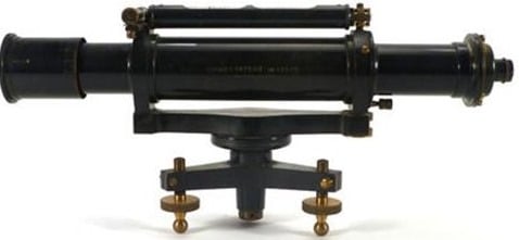
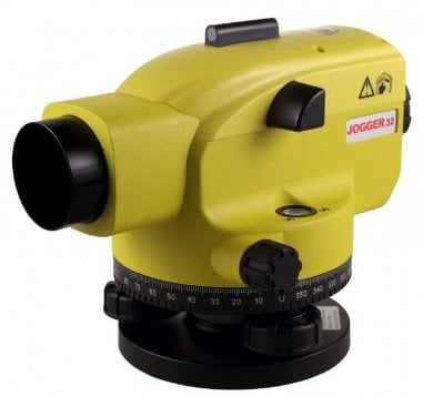
Dumpy Level
Dumpy level is the most commonly used instrument in leveling. In this level the telescope is restricted against movement in its horizontal plane and telescope is fixed to its support. A bubble tube is provided on the top of the telescope.
But however, the leveling head can be rotated in horizontal plane with the telescope. The telescope is internal focusing telescope is a metal tube contains four main parts as given below.
Objective lens
Negative lens
Diaphragm
Eye-piece
Objective Lens
Objective lens should be made as the combination of crown glass and flint glass. Because of this some defects like spherical aberration and chromatic aberration can be eliminated. A thin layer coating which has smaller refractive index than glass is provided on the objective lens to reduce the loss due to reflection.
Negative Lens
Negative lens located co axial to the objective lens. So, the optical axis for both lenses is same.
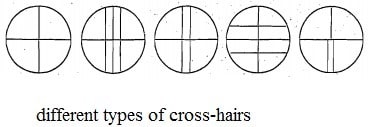
Diaphragm
Diaphragm is fitted inside the main tube which contains cross hairs (vertical and horizontal) and these are adjusted by capstan headed screws. The cross hairs are made of dark metal as filament wires which are inserted in diaphragm ring in exact position. For stadia leveling purposes, extra two horizontal cross hairs are provided above and below the horizontal wire.
Eyepiece
Eyepiece lens enable the ability to sight the object together with cross hairs. The image seen through eye piece is magnified and inverted. Some eyepieces erect the image into normal view and those are called as erecting eyepieces.
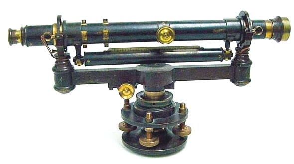
Y Level
Y level or Wye-level consists y-shaped frames which supports the telescope. Telescope cane be removed from the y-shaped supports by releasing clamp screws provided. These y-shaped frames are arranged to vertical spindle which helps to cause the rotation of telescope.
Compared to dumpy level, adjustments can be rapidly tested in y- level. But, there may be a chance of frictional wear of open parts of level.
Cushing’s Level
In case of Cushing’s level, the telescope is restricted against rotation in its longitudinal axis and it is non-removable. But, the object end and eye piece end can be interchangeable and reversible.
Tilting Level
Tilting level consist a telescope which enabled for the horizontal rotation as well as rotation about 4 degree in its vertical plane. Centering of bubble can be easily done in this type of level. But, for every setup bubble is to be centered with the help of tilting screw.
The main advantage of tilting level is it is useful when the few observations are to be taken with one setup of level.

Cooke’s Reversible Level
Cooke’s reversible level is the combination of dumpy level and y-level. In this instrument, the telescope can be reversed without rotation the instrument. Collimation error can be eliminated in this case because of bubble left and bubble right reading of telescope.
Automatic Level
Automatic level is like the dumpy level. In this case the telescope is fixed to its supports. Circular spirit can be attached to the side of the telescope for approximate leveling. For more accurate leveling, compensator is attached inside the telescope.

Compensator can help the instrument to level automatically. Compensator is also called as stabilizer which consists two fixed prisms and it creates an optical path between eye piece and objective.
Due to the action of gravity, the compensator results the optical system to swing into exact position of line of sight automatically. But before the process of leveling, compensator should be checked.
To check the compensator, just move the foot screws slightly if the leveling staff reading remains constant then compensator is perfect. If it is not constant, then tap the telescope gently to free the compensator. Automatic level is also called as self-adjusting level.
Types of Leveling Methods used in Surveying
Types of Leveling Methods used in Surveying
Types of Leveling Methods used in Surveying
There are various types of leveling used in surveying for measurement of level difference of different points with respect to a fixed point. This is useful in various civil engineering construction works where levels of different structures need to be maintained as per drawing.
Table of Contents [hide]
2 Types of Leveling in Surveying
What Is Leveling?
Leveling is a branch of surveying in civil engineering to measure levels of different points with respect to a fixed point such as elevation of a building, height of one point from ground etc.
Types of Leveling in Surveying
Direct leveling
Trigonometric leveling
Barometric leveling
Stadia leveling
Direct Leveling
It is the most commonly used method of leveling. In this method, measurements are observed directly from leveling instrument.
Based on the observation points and instrument positions direct leveling is divided into different types as follows:
Simple leveling
Differential leveling
Fly leveling
Profile leveling
Precise leveling
Reciprocal leveling
Simple Leveling
It is a simple and basic form of leveling in which the leveling instrument is placed between the points which elevation is to be find. Leveling rods are placed at that points and sighted them through leveling instrument. It is performed only when the points are nearer to each other without any obstacles.
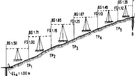
Differential Leveling
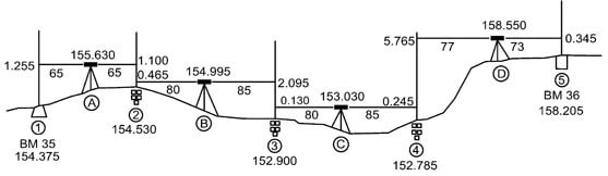
Differential leveling is performed when the distance between two points is more. In this process, number of inter stations are located and instrument is shifted to each station and observed the elevation of inter station points. Finally difference between original two points is determined.
Fly Leveling
Fly leveling is conducted when the benchmark is very far from the work station. In such case, a temporary bench mark is located at the work station which is located based on the original benchmark. Even it is not highly precise it is used for determining approximate level.
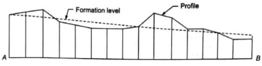
Profile Leveling
Profile leveling is generally adopted to find elevation of points along a line such as for road, rails or rivers etc. In this case, readings of intermediate stations are taken and reduced level of each station is found. From this cross section of the alignment is drawn.
Precise Leveling
Precise leveling is similar to differential leveling but in this case higher precise is wanted. To achieve high precise, serious observation procedure is performed. The accuracy of 1 mm per 1 km is achieved.
Reciprocal Leveling
When it is not possible to locate the leveling instrument in between the inter visible points, reciprocal leveling is performed. This case appears in case of ponds or rivers etc. in case of reciprocal leveling, instrument is set nearer to 1ststation and sighted towards 2nd station.

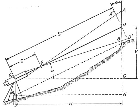
Trigonometric Leveling
The process of leveling in which the elevation of point or the difference between points is measured from the observed horizontal distances and vertical angles in the field is called trigonometric leveling.
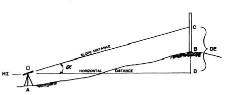
In this method, trigonometric relations are used to find the elevation of a point from angle and horizontal distance so, it is called as trigonometric leveling. It is also called as indirect leveling.
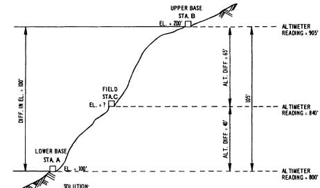
Barometric Leveling
Barometer is an instrument used to measure atmosphere at any altitude. So, in this method of leveling, atmospheric pressure at two different points is observed, based on which the vertical difference between two points is determined. It is a rough estimation and used rarely.
Stadia Leveling
It is a modified form of trigonometric leveling in which Tacheometer principle is used to determine the elevation of point. In this case the line of sight is inclined from the horizontal. It is more accurate and suitable for surveying in hilly terrains.
Read More: Types of Levels Used for Leveling in Surveying
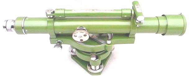
Dumpy Level
Dumpy Level

The dumpy level originally designed by Gravatt, consists of a telescope tube firmly secured in two collars fixed by adjusting screws to the stage carried by the vertical spindle. The modern form of dumpy level has the telescope tube and the vertical spindle cast in one piece and a long bubble tube is attached to the top of the telescope. This form is known as solid dumpy.
Components of Dumpy Level
The name “dumpy level” originated from the fact that formerly this level was equipped with an inverting eye-piece and hence was shorter than Wye level of the same magnifying power. However, modern forms of dumpy level generally have erecting eye-piece so that inverted image of the staff is visible in the field of view. In some of the instruments, a clamp screw is provided to control the movements of the spindle about the vertical axis. For small or precise movement, a slow motion screw ( or tangent screw) is also provided. Some of the important parts of Dumpy Level are listed and described below:

Tripod Stand: The tripod consists of three legs which may be solid or framed. The legs are made of light and hard wood. The lower ends of the legs are fitted with steel shoes.
Levelling head: The levelling head consists of two parallel triangular plates having three grooves to support the foot screws.
Foot screws: Three foot screws are provided between the trivet and tribrach. By turning the foot screws the tribrach can be raised or lowered to bring the bubble to the center of its run.
Telescope: The telescope consists of two metal tubes, one moving within the other. It also consists of an object glass and an eye-piece on opposite ends. A diaphragm is fixed with the telescope just in front of the eye-piece. The diaphragm carries cross-hairs. The telescope is focused by means of the focusing screw and may have either external focusing, or internal focusing.
In the external focusing telescope, the diaphragm is fixed to the outer tube and the objective to the inner tube. By turning the focusing screw the distance between the objective and diaphragm is altered to form a real image or the plane of cross hairs.
In the internal focusing telescope, the objective and eye-piece do not move when the focusing screw is turned. Here, a double concave lens is fitted with rack and pinion arrangement between the eye-piece and the objective. This lens moves to and fro when the focusing screw is turned and a real image is formed on the plane of cross-hairs.
Bubble tubes: Two bubble tubes, one called the longitudinal bubble tube and other the cross bubble tube, are placed at right angles to each other. These tubes contain spirit bubble. The bubble is brought to the center with the help of foot screws. The bubble tube are fixed on top of the telescope.
Compass: A compass is provided just below the telescope for taking the magnetic bearing of a line when required.
The compass is graduated in such a way that a ‘pointer’, which is fixed to the body of compass, indicates a reading of 0 degree when the telescope is directed along the north line.In some compasses, the pointer shows a reading of a few degrees when the telescope is directed towards the north. This reading should be taken as the initial reading. The bearing is obtained by deducting the initial reading from the final reading of the compass.
Advantages of Dumpy Level
The advantages of dumpy level over the Wye Level are:
Simpler construction with fewer movable parts.
Fewer adjustments to be made.
Longer life of the adjustments.
Level and Leveling
LEVELLING
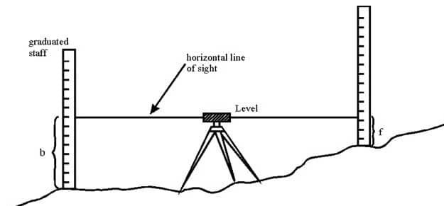
Levelling (or Leveling) is a branch of surveying, the object of which is: i) to find the elevations of given points with respect to a given or assumed datum, and ii) to establish points at a given or assumed datum. The first operation is required to enable the works to be designed while the second operation is required in the setting out of all kinds of engineering works. Levelling deals with measurements in a vertical plane.
Level surface: A level surface is defined as a curved surface which at each point is perpendicular to the direction of gravity at the point. The surface of a still water is a truly level surface. Any surface parallel to the mean spheroidal surface of the earth is, therefore, a level surface.
Level line: A level line is a line lying in a level surface. It is, therefore, normal to the plumb line at all points.
Horizontal plane: Horizontal plane through a point is a plane tangential to the level surface at that point. It is, therefore, perpendicular to the plumb line through the point.
Horizontal line: It is a straight line tangential to the level line at a point. It is also perpendicular to the plumb line.
Vertical line: It is a line normal to the level line at a point. It is commonly considered to be the line defined by a plumb line.
Datum: Datum is any surface to which elevation are referred. The mean sea level affords a convenient datum world over, and elevations are commonly given as so much above or below sea level. It is often more convenient, however, to assume some other datum, specially, if only the relative elevation of points are required.
Elevation: The elevation of a point on or near the surface of the earth is its vertical distance above or below an arbitrarily assumed level surface or datum. The difference in elevation between two points is the vertical distance between the two level surface in which the two points lie.
Vertical angle: Vertical angle is an angle between two intersecting lines in a vertical plane. Generally, one of these lines is horizontal.
Mean sea level: It is the average height of the sea for all stages of the tides. At any particular place it is derived by averaging the hourly tide heights over a long period of 19 years.
Bench Mark: It is a relatively permanent point of reference whose elevation with respect to some assumed datum is known. It is used either as a starting point for levelling or as a point upon which to close as a check.
Methods of levelling
Three principle methods are used for determining differences in elevation, namely, barometric levelling, trigonometric levelling and spirit levelling.
Barometric levelling
Barometric levelling makes use of the phenomenon that difference in elevation between two points is proportional to the difference in atmospheric pressures at these points. A barometer, therefore, may be used and the readings observed at different points would yield a measure of the relative elevation of those points.
At a given point, the atmospheric pressure doesn’t remain constant in the course of the day, even in the course of an hour. The method is, therefore, relatively inaccurate and is little used in surveying work except on reconnaissance or exploratory survey.
Trigonometric Levelling (Indirect Levelling)
Trigonometric or Indirect levelling is the process of levelling in which the elevations of points are computed from the vertical angles and horizontal distances measured in the field, just as the length of any side in any triangle can be computed from proper trigonometric relations. In a modified form called stadia levelling, commonly used in mapping, both the difference in elevation and the horizontal distance between the points are directly computed from the measured vertical angles and staff readings.
Spirit Levelling (Direct Levelling)
It is that branch of levelling in which the vertical distances with respect to a horizontal line (perpendicular to the direction of gravity) may be used to determine the relative difference in elevation between two adjacent points. A horizontal plane of sight tangent to level surface at any point is readily established by means of a spirit level or a level vial. In spirit levelling, a spirit level and a sighting device (telescope) are combined and vertical distances are measured by observing on graduated rods placed on the points. The method is also known as direct levelling. It is the most precise method of determining elevations and the one most commonly used by engineers.
Levelling Instruments
The instruments commonly used in direct levelling are:
A level
A levelling staff