Showing posts with label Solving spherical triangles. Show all posts

Sunday, 11 November 2018

QUESTION: DESCRIBE THE SOURCES OF ERROR IN LEVELING


            DESCRIBE THE SOURCES OF ERROR IN LEVELING
Image result for reciprocal levelling

            Many sources of error exist in levelling and the most commonly met in practice are discussed. Firstly, one of the sources of error is errors in the equipment which is collimation error. This can be a serious source of error in levelling if the sight lengths from one instrument position are not equal, since the collimation error proportional to the difference in sight length. The line of collimation should be parallel to the line of sights. 
Image result for reciprocal levelling
Hence, in all types of levelling, sights should kept equal, particularly back sights and fore sights. Before using any level it is advisable to carry out a two-peg to ensure that the collimation error is as small as possible. Other than that, compensator not working. The function of compensator is to deviate the horizontal ray of light at the optical center of the object lens through the center of the cross hairs. This ensure that line of sight viewed through the telescope is horizontal.  
Image result for reciprocal levelling
If the reading changes to a different position each time the footscrew is moved or thr instrument tapped, the compensator is not working properly and the instrument should be returned to the manufacturer for repair. Parallax  also one of error in the equipment. Parallax must be eliminated before any readings are taken. Parallax is occur when the image of the distance point or object and focal plane are not fall exactly in the plane of the diaphragm. 
Image result for reciprocal levelling
To eliminate parallax, the eyepiece is first adjusted until the cross hairs appear in sharp focus. Then, defects on the staff  which is the incorrect graduation staff cause the zero error. This does not effect height differences if the same staff is used for all the levelling but introduces errors if to staves used for the same series of levels. When using a multisection staff, it is important to unsure that it is properly extended by examining the graduations on either side of each joint. The stability of tripods should also be checked before any fieldwork commences .
Image result for reciprocal levelling 
                     Secondly, field errors also source of error. The example of field errors is staff not vertical, failure to hold the staff vertical will result in incorrect readings. The staff is held vertical with the aid of a circular bubble. At frequent intervals the circular bubble should checked against plumb line and adjusted if necessary. Another example of field errors is unstable ground. When the instrument is set up on soft ground and bituminous surfaces on hot days, an effect often overlooked is that the tripod legs may sink into the ground or rise slightly while readings are being taken.This alters the height collimation and therefore advisable to choose firm ground on which to set up the level. 

After that, handling the instrument and tripod as well as vertical displacement, the HPC may be altered for any set-up if the tripod is held or leant against. When levelling, avoid contact with the tripod and only use the level by light contact through the fingertips. Then, instrument not level is also the field errors. For automatic levels this source of error is unusual but, for tilting level in which the tilting screw has to be adjusted for each reading, this is common mistake. The best solution is to ensure the main bubble is centralised before and after reading.
 Image result for reciprocal levelling
                 Thirdly, source of error is the effects of curvature and refraction on levelling. The effect of atmospheric on the line of sight is to bend it towards the Earth’s surface causing staff readings to be too low. This is variable effect depending on atmospheric condition but for ordinary work refraction is assumed to have value 1/7 that of curvature bit is of opposite sign. The combined and refraction correction is c + r = 0.0673 D². If longer sight lengths must be used, it is worth remembering that the effects of curvature and refraction will cancel if the sight length are equal. But, curvature and refraction cannot always be ignored when calculating heights using theodolite methods.
 Image result for reciprocal levelling
                  Lastly, source of error is reading and booking error and also weather conditions. Source of reading error is the sighting the staff over too long a distance, when it becomes impossible to take accurate readings. It is , therefore, recommended that sighting distances should be limited to 50m but, where absolutely unavoidable, this may be increased to maximum of 100m. For weather conditions, when it windy will cause the level to vibrate and give rise to difficulties in holding the staff steady. In hot weather, the effect of refraction are serious and produce a shimmering effect near ground level. The reading cannot be read accurately.


Friday, 21 September 2018

TRAVERSE CALCULATIONS- PROCEDURE

TRAVERSE CALCULATIONS

PROCEDURE FOR TRAVERSE CALCULATIONS

  • Adjust angles or directions
  • Determine bearings or azimuths
  • Calculate and adjust latitudes and departures
  • Calculate rectangular coordinates

    BALANCING ANGLES OF CLOSED TRAVERSES


    An example of a calculation involving interior angles is available.

    ADJUSTING ANGLES

  • Adjustments applied to angles are independent of the size of the angle
  • Methods of adjustment:
      Make larger corrections where mistakes were most likely
      Apply an average correction to each angle
      Or a combination
  • Never make an adjustment that is smaller than the measured accuracy

    DETERMINING BEARINGS OR AZIMUTHS

  • Requires the direction of at least one line within the traverse to be known or assumed
  • For many purposes, an assumed direction is sufficient
  • A magnetic bearing of one of the lines may be measured and used as the reference for determining the other directions
  • For boundary surveys, true directions are needed

    LATITUDES AND DEPARTURES

  • The latitude of a line is its projection on the north-south meridian and is equal to the length of the line times the cosine of its bearing
  • The departure of a line is its projection on the east-west meridian and is equal to the length of the line times the sine of its bearing
  • The latitude is the y component of the line and the departure is the x component of the line

    LATITUDES AND DEPARTURES


    CLOSURE OF LATITUDES AND DEPARTURES

  • The algebraic sum of all latitudes must equal zero or the difference in latitude between the initial and final control points
  • The algebraic sum of all departures must equal zero or the difference in departure between the initial and final control points

    CALCULATION OF LATITUDES AND DEPARTURES

    Using bearings
    StationBearingLengthLatitudeDeparture
    A
    N 26° 10'E285.10+255.88+125.72
    B
    S 75° 25'E610.45-153.70+590.78
    C
    S 15° 30'W720.48-694.28-192.54
    D
    N 1° 42'W203.00+202.91-6.02
    E
    N 53° 06'W647.02+388.48-517.41
    A
    MISCLOSURE-0.71+0.53

    CALCULATION OF LATITUDES AND DEPARTURES

    Using azimuths
    StationAzimuthLengthLatitudeDeparture
    A
    26° 10'285.10+255.88+125.72
    B
    104° 35'610.45-153.70+590.78
    C
    195° 30'720.48-694.28-192.54
    D
    358° 18'203.00+202.91-6.02
    E
    306° 54'647.02+388.48-517.41
    A
    MISCLOSURE-0.71+0.53

    ADJUSTMENT OF LATITUDES AND DEPARTURES

    Compass (Bowditch) Rule 

    ADJUSTMENT OF LATITUDES AND DEPARTURES

    StationAzimuthLengthLatitudeDeparture
    A+0.08-0.06
    26° 10'285.10+255.88+125.72
    B+0.18-0.13
    104° 35'610.45-153.70+590.78
    C+0.21-0.15
    195° 30'720.48-694.28-192.54
    D+0.06-0.05
    358° 18'203.00+202.91-6.02
    E+0.18-0.14
    306° 54'647.02+388.48-517.41
    A
    TOTALS2466.05-0.71+0.53

    ADJUSTMENT OF LATITUDES AND DEPARTURES

    BalancedBalanced
    StationLatitudeDepartureLatitudeDeparture
    A+0.08-0.06
    +255.88+125.72+255.96+125.66
    B+0.18-0.13
    -153.70+590.78-153.52+590.65
    C+0.21-0.15
    -694.28-192.54-694.07-192.69
    D+0.06-0.05
    +202.91-6.02+202.97-6.07
    E+0.18-0.14
    +388.48-517.41+388.66-517.55
    A
    TOTALS-0.71+0.530.000.00

    RECTANGULAR COORDINATES

  • Rectangular X and Y coordinates of any point give its position with respect to a reference coordinate system
  • Useful for determining length and direction of lines, calculating areas, and locating points
  • You need one starting point on a traverse (which may be arbitrarily defined) to calculate the coordinates of all other points
  • A large initial coordinate is often chosen to avoid negative values, making calculations easier.

    CALCULATING X AND Y COORDINATES

    Given the X and Y coordinates of any starting point A, the X and Y coordinates of the next point B are determined by:


    COORDINATES

    BalancedBalanced
    StationLatitudeDepartureY-coordX-coord
    A10000.0010000.00
    +255.96+125.66
    B10255.9610125.66
    -153.52+590.65
    C10102.4410716.31
    -694.07-192.69
    D9408.3710523.62
    +202.97-6.07
    E9611.3410517.55
    +388.66-517.55
    A10000.0010000.00
    TOTALS0.000.00

    LINEAR MISCLOSURE

    The hypotenuse of a right triangle whose sides are the misclosure in latitude and the misclosure in departure.


    TRAVERSE PRECISION

  • The precision of a traverse is expressed as the ratio of linear misclosure divided by the traverse perimeter length.
  • expressed in reciprocal form
  • Example
      0.89 / 2466.05 = 0.00036090
      1 / 0.00036090 = 2770.8

      Precision = 1/2771
  • Tuesday, 2 May 2017

    Solving spherical triangles

    Solving spherical triangles Edit The general spherical triangle is fully determined by three of its six characteristics (3 sides and 3 angles). Note that the sides a, b, c of a spherical triangle are measured by angular rather than linear units, based on the corresponding central angles. The solution of triangles for non-Euclidean spherical geometry has some differences from the planar case. For example, the sum of the three angles α + β + γ depends on the triangle. In addition, there are no unequal similar triangles, and so the problem of constructing a triangle with specified three angles has a unique solution. The basic relations used to solve a problem are similar to those of the planar case: see Law of cosines (spherical) and Law of sines (spherical). Among other relationships that may be useful are the half-side formula and Napier's analogies:[7] {\displaystyle \tan {\frac {c}{2}}\cos {\frac {\alpha -\beta }{2}}=\tan {\frac {a+b}{2}}\cos {\frac {\alpha +\beta }{2}}} {\displaystyle \tan {\frac {c}{2}}\sin {\frac {\alpha -\beta }{2}}=\tan {\frac {a-b}{2}}\sin {\frac {\alpha +\beta }{2}}} {\displaystyle \cot {\frac {\gamma }{2}}\cos {\frac {a-b}{2}}=\tan {\frac {\alpha +\beta }{2}}\cos {\frac {a+b}{2}}} {\displaystyle \cot {\frac {\gamma }{2}}\sin {\frac {a-b}{2}}=\tan {\frac {\alpha -\beta }{2}}\sin {\frac {a+b}{2}}.}  Three sides given Three sides given (spherical SSS) Edit Known: the sides a, b, c (in angular units). The triangle's angles are computed from the spherical law of cosines: {\displaystyle \alpha =\arccos \left({\frac {\cos a-\cos b\ \cos c}{\sin b\ \sin c}}\right),} {\displaystyle \beta =\arccos \left({\frac {\cos b-\cos c\ \cos a}{\sin c\ \sin a}}\right),} {\displaystyle \gamma =\arccos \left({\frac {\cos c-\cos a\ \cos b}{\sin a\ \sin b}}\right).}  Two sides and the included angle given Two sides and the included angle given (spherical SAS) Edit Known: the sides a, b and the angle γ between them. The side c can be found from the law of cosines: {\displaystyle c=\arccos \left(\cos a\cos b+\sin a\sin b\cos \gamma \right).} The angles α', β can be calculated as above, or by using Napier's analogies: {\displaystyle \alpha =\arctan \ {\frac {2\sin a}{\tan({\frac {\gamma }{2}})\sin(b+a)+\cot({\frac {\gamma }{2}})\sin(b-a)}},} {\displaystyle \beta =\arctan \ {\frac {2\sin b}{\tan({\frac {\gamma }{2}})\sin(a+b)+\cot({\frac {\gamma }{2}})\sin(a-b)}}.} This problem arises in the navigation problem of finding the great circle between two points on the earth specified by their latitude and longitude; in this application, it is important to use formulas which are not susceptible to round-off errors. For this purpose, the following formulas (which may be derived using vector algebra) can be used: {\displaystyle {\begin{aligned}c&=\arctan {\frac {\sqrt {(\sin a\cos b-\cos a\sin b\cos \gamma )^{2}+(\sin b\sin \gamma )^{2}}}{\cos a\cos b+\sin a\sin b\cos \gamma }},\\\alpha &=\arctan {\frac {\sin a\sin \gamma }{\sin b\cos a-\cos b\sin a\cos \gamma }},\\\beta &=\arctan {\frac {\sin b\sin \gamma }{\sin a\cos b-\cos a\sin b\cos \gamma }},\end{aligned}}} where the signs of the numerators and denominators in these expressions should be used to determine the quadrant of the arctangent.  Two sides and a non-included angle given Two sides and non-included angle given (spherical SSA) Edit This problem is not solvable in all cases; a solution is guaranteed to be unique only if the side length adjacent to the angle is shorter than the other side length. Known: the sides b, c and the angle β not between them. A solution exists if the following condition holds: {\displaystyle b>\arcsin(\sin c\,\sin \beta ).} The angle γ can be found from the spherical law of sines: {\displaystyle \gamma =\arcsin \left({\frac {\sin c\,\sin \beta }{\sin b}}\right).} As for the plane case, if b < c then there are two solutions: γ and 180° - γ. We can find other characteristics by using Napier's analogies: {\displaystyle a=2\arctan \left[\tan \left({\tfrac {1}{2}}(b-c)\right){\frac {\sin \left({\tfrac {1}{2}}(\beta +\gamma )\right)}{\sin \left({\tfrac {1}{2}}(\beta -\gamma )\right)}}\right],} {\displaystyle \alpha =2\operatorname {arccot} \left[\tan \left({\tfrac {1}{2}}(\beta -\gamma )\right){\frac {\sin \left({\tfrac {1}{2}}(b+c)\right)}{\sin \left({\tfrac {1}{2}}(b-c)\right)}}\right].}  One side and two adjacent angles given A side and two adjacent angles given (spherical ASA) Edit
    Three angles given (spherical AAA)Edit
    Known: the angles αβγ. From the law of cosines we infer:
    {\displaystyle a=\arccos \left({\frac {\cos \alpha +\cos \beta \cos \gamma }{\sin \beta \sin \gamma }}\right),}{\displaystyle b=\arccos \left({\frac {\cos \beta +\cos \gamma \cos \alpha }{\sin \gamma \sin \alpha }}\right),}{\displaystyle c=\arccos \left({\frac {\cos \gamma +\cos \alpha \cos \beta }{\sin \alpha \sin \beta }}\right).}
    Solving right-angled spherical trianglesEdit
    The above algorithms become much simpler if one of the angles of a triangle (for example, the angle C) is the right angle. Such a spherical triangle is fully defined by its two elements, and the other three can be calculated usingNapier's Pentagon or the following relations.
    {\displaystyle \sin a=\sin c\cdot \sin A} (from the Law of sines (spherical)){\displaystyle \tan a=\sin b\cdot \tan A}{\displaystyle \cos c=\cos a\cdot \cos b} (from the law of cosines (spherical)){\displaystyle \tan b=\tan c\cdot \cos A}{\displaystyle \cos A=\cos a\cdot \sin B} (also from the law of cosines){\displaystyle \cos c=\cot A\cdot \cot B}
    Some applicationsEdit
    TriangulationEdit
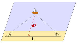
    Distance measurement by triangulation
    Main article: Triangulation
    If one wants to measure the distance dfrom shore to a remote ship via triangulation, one marks on the shore two points with known distance lbetween them (the baseline). Let αβ be the angles between the baseline and the direction to the ship.
    From the formulae above (ASA case) one can define the length of the triangle height:
    {\displaystyle d={\frac {\sin \alpha \,\sin \beta }{\sin(\alpha +\beta )}}\,l={\frac {\tan \alpha \,\tan \beta }{\tan \alpha +\tan \beta }}\,l.}
    This method is used in cabotage. The angles αβ are defined by observation of familiar landmarks from the ship.
    How to measure a mountain's height
    As another example, if one wants to measure the height h of a mountain or a high building, the angles αβ from two ground points to the top are specified. Let l be the distance between these points. From the same ASA case formulas we obtain:
    {\displaystyle h={\frac {\sin \alpha \,\sin \beta }{\sin(\beta -\alpha )}}\,l={\frac {\tan \alpha \,\tan \beta }{\tan \beta -\tan \alpha }}\,l.}
    The distance between two points on the globeEdit
    Main article: Great-circle distance
    To calculate the distance between two points on the globe,
    Point A: latitude λA, longitude LA, andPoint B: latitude λB, longitude LB
    we consider the spherical triangle ABC, where C is the North Pole. Some characteristics are:
    {\displaystyle a=90^{\mathrm {o} }-\lambda _{\mathrm {B} },\,}{\displaystyle b=90^{\mathrm {o} }-\lambda _{\mathrm {A} },\,}{\displaystyle \gamma =L_{\mathrm {A} }-L_{\mathrm {B} }.\,}
    If two sides and the included angle given, we obtain from the formulas
    {\displaystyle \mathrm {AB} =R\arccos \left[\sin \lambda _{\mathrm {A} }\,\sin \lambda _{\mathrm {B} }+\cos \lambda _{\mathrm {A} }\,\cos \lambda _{\mathrm {B} }\,\cos \left(L_{\mathrm {A} }-L_{\mathrm {B} }\right)\right].}
    Here R is the Earth's radius.